Targeted property condition assessments are fundamental to any asset manager’s role. The resulting data is the foundation for operational and strategic decision-making. Getting the information required for these inspections can sometimes be challenging, especially accessing roofs or similar areas due to ‘working at height’ safety compliance and access issues.
In late 2019, our survey team trialed drones to safely inspect areas of a building that would normally be challenging to access. The objective was to provide a more complete assessment of roofing assets at a minimal cost. Although this practice is already widely used, it can be time consuming and expensive – we wanted to know whether it could be done as part of our standard survey process rather than it being seen as a specialist inspection at higher cost.
How did we use a drone for inspections?
The drone was tested on three different projects, with buildings ranging from 16 stories in the city to heritage buildings in a rural town to blocks of units. All of these buildings had a similar issue – limited roof access – either due to the type of roof or the requirement for a harness. Normal survey methods would mean these roofs would be assessed from the ground, a nearby building, interviewing the facility manager, or through satellite pictures.
A slow flyby of each roof was undertaken – including close-in flights to gather stills and video of any areas of interest or equipment to gain detailed information.
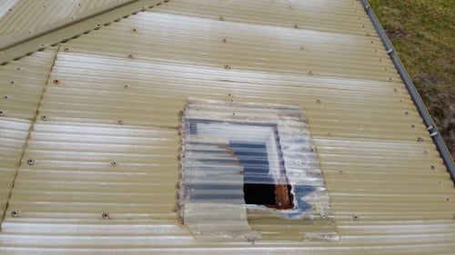
Because of the small size of the drone, we were able to get close to equipment and targeted areas of interest such as rusting gutters, missing flashings, and broken sky lights. Even in windy conditions the drone was able to stay localized and stable.
The resulting videos and photos enabled a more complete assessment of each building. We were able to:
- survey a steeply pitched roof, with no access or safety system fitted (heritage)
- photo cracking in render and solid brick both from both roof and “space” sides
- access external sides of a building with restricted access from ground
- identify the cause of a hole in roof with no access
- take close up pictures of a rotten facia board, with no ground line of sight
What this means for our survey process:
- Roofs can be surveyed with reduced risk to surveyors
- Video and/or photo overview of externals and roofs can be provided and stored for reference
- Roof and hard to access externals can be surveyed with less impact to the client or extra permits or equipment needed
- A roof survey is faster, only areas needing detailed inspection are focused on
- All areas of the roof can be seen
- The smaller sized drone was easy to carry
- Three batteries in kit along with USB recharge allows for multiple or large buildings to be done quickly
What sort of device did we use?
If you’re interested in the technology used for trial the drone selected was a DJI Mavic Mini, chose because:
- The folding nature of the drone for easy portability by the surveyor
- Long battery life – 20 to 30 minutes per battery
- Ability to rotate camera from 100 above horizontal to 900 down.
- Use of iPad/tablet/phone for control, image viewing and saving of images.
- Light weight – 249g, under the requirements of needing a Commercial Drone Licence
- assuming line of sight daytime flying
- Ability to be used in most semi restricted airspace – after compliance and unlocking submission
- Auto hover and smooth flight even in medium winds
- Gyroscope gimbaled camera for smooth video
- Ability to take video and stills
One of the challenges was the time taken to setup the drone, fly the building, transfer the images and videos to the Asset Register at property and component level, and to translate these images into asset data that can be used for analysis and works-programming. We needed to prove that the additional time needed to complete these steps was of value.
The result – yes, it takes more time which results in more cost to the survey. However, the time and costs would be a fraction of traditional methods of inspection such as cherry-pickers or being trained to use a harness. We would recommend that survey projects separately identify which roofs need a more detailed assessment and that the survey budget recognizes these – our preference is that a provisional cost budget is assigned to each survey project and agree on which buildings should be targeted.
In determining whether drones are right for your project, consider the locations of the buildings and if there are any drone flight restrictions – this can limit the type of buildings being assessed especially within urban and city environments.